Death Valley National Park

Zabriskie Point is the Delicate Arch of Death Valley National Park and people gather there at sunset. Being only 15 minutes away from the main Furnace Creek area by car, it is undeniably one of the most popular spots. It is only a 0,1 mile hike up a steep paved path to the viewpoint. Bring warm clothes if it is cold, it can get crazy windy there.
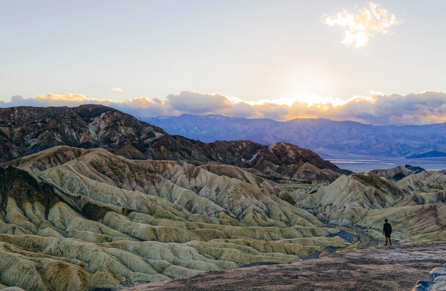
Zabriskie Point was named after Christian Zabriskie who was the general manager of the Pacific Coast Borax Company, which was huge in Death Valley during the borax mining days. The view has been featured in many pop culture references as well, with the most notable being the Joshua Tree album cover for the band U2.

Most people know that Badwater Basin in Death Valley National Park is the lowest point in North America (282 ft below sea level), but there's something even more fascinating about that place. When rainstorms flood the valley bottom like it did in the last few weeks, the salt expanse is covered with a thin sheet of standing water. Each newly-formed lake does not last long, because the 1.9 inches of average rainfall is overwhelmed by a 150-inch annual evaporation rate. This means that even a 12-foot-deep, 30-mile-long lake would dry up in a single year!!! How crazy is that?

From the parking lot, you can see the sea level sign that is located 280 feet above you on the adjacent mountain. It really puts in perspective how low you are when you see it compared to the mountain.

Look at those cool salt crystals! You can even taste them!

As soon as you enter the walk out on the platform you are immediately greeted with a huge lake of what looks like snow. This water is so high is salt content that almost nothing can actually live there. The salt flat itself is 5 miles long. Badwater Basin is a truly unique place to stop. You don’t need a lot of time here, but it is worth checking out. Also note that it is very often windy there.

Golden Canyon is one of the many sites where different parts of the original Star Wars movies were filmed. It is the most popular hike in all of Death Valley National Park and is a little over 3 miles round trip, depending on where you stop. The parking lot is about 10 minutes South of Furnace Creek.

It has gaping canyons, massive boulders, waves of plantless terrain and even a large red rock called the Red Cathedral at the end. You can totally picture a few stormtroopers appearing around a boulder. You can see some of the reconstructed scenes vs the original scene here.

Approaching the Red Cathedral (in the back).

After leaving Death Valley from the south west road, we decided to stop to visit another geologically interesting place near Searles Lakes. When you visit Trona Pinnacles, you cannot help but feel like you are on the moon or on another planet. The unusual landscape is made up of more than 500 spires, some as high as 140 feet, rising from the bed of the Searles Dry Lake basin. The pinnacles vary in size and shape from short and wide to tall and thin, and are composed primarily of calcium carbonate (tufa), like those found in Mono Lake. The pinnacles were formed underwater from 10,000 to 100,000 years ago when Searles Lake was one of a chain of interconnected Pleistocene lakes stretching from Mono Lake to Death Valley.

The Trona Pinnacles are not in Death Valley, they are truly in the middle of nowhere, about 25 minutes east of Ridgecrest, and are one of those places that have to be seen to be believed. Like the Alabama Hills, it is hard to do justice to the sheer beauty of these massive rock structures that jot a landscape that is almost entirely barren and flat.
The Pinnacles are recognizable in more than a dozen movies. Over thirty film projects a year are shot among the tufa pinnacles, including backdrops for car commercials and sci-fi movies and television series such as Battlestar Galactica, Star Trek V: The Final Frontier, Disney's Dinosaur, The Gate II, Lost in Space, Planet of the Apes, and more recently the movie Holes.

There is a short half mile hiking trail, but you can drive around easily in a 4 x 4 vehicle to see the formations. They were more impressive from afar in my opinion. There are designated camping spots and the area is very well defined with rocks to prevent driving over the fragile areas. Please set up camp only where there is already a fire ring outside of the rock-fenced areas. There was no usable cell signal there.
We have decided to camp at Texas Spring Campground, since it is the cheapest and the more beautiful. There are no services and a no generator rule. There is a dump, water and toilet on site. Note that for 5$ per person (during the week, $10 on weekends), you can access the hotel warm fed spring pool and showers. The pool was just too cold - 85 F - to be comfortable when we were there (it was cold and windy that night). Note that you only need one card ($5) to enter the pool and shower area and that there is no lifeguard or staff on duty there, so decide accordingly ;)
There are more hikes and sights to see in Death Valley, but some were closed when we were there since the recent rains had washed out the roads or there were closures due to construction. We wanted to hike Mosaic Canyon, check out Scotty’s Castle and bike Titus Canyon, but couldn’t.
We passed on the Mesquite sand dunes since we had just been at the Kelso dunes in the Mojave desert (that are bigger and more impressive) and the Racetrack (those moving rocks that have left tracks behind them) since it is located at the end of rough dirt road and is an adventure in itself.
*Be advised that exiting Death Valley through the west (road from Stovepipe Wells to Panamint Springs) requires driving a very long twisty downhill section that could be hard on your brakes if you tow a trailer or drive a motorhome. We separated the Westy from the bus for the long climb and descent and it still was a bit nerve-wracking, glad we have a brake retarder on the bus. A friends’ brakes caught on fire there. Be warned and drive slow.
Interesting facts about Death Valley:
Death Valley National Park is the largest national park in the Lower 48 at a whopping more than 3.4 million acres.
The highest recorded temperature in the world was recorded in Death Valley’s Furnace Creek at 134 Fahrenheit in July, 1913. For almost one hundred years, a false recording made in Libya overshadowed Furnace Creek’s claim to fame. In 2012, however, the record went back to Death Valley after it was concluded that the Libyan recording was made in error.
Death Valley is only 76 miles from the highest point in the country, Mt. Whitney, which tops out at an elevation of 14,505 feet. In other words, the lowest and highest points in the contiguous U.S. are less than 100 miles apart!
There is every year an ultramarathon in Death Valley called the Badwater 135, which links these two points! The race organizers description goes like this : Covering 135 miles (217 km) non-stop from Death Valley to Mt. Whitney, CA, the Badwater 135 is the most demanding and extreme running race offered anywhere on the planet. The start line is at Badwater Basin, Death Valley, which marks the lowest elevation in North America at 280’ (85m) below sea level. The race finishes at Whitney Portal at 8,300’ (2530m), which is the trailhead to the Mt. Whitney summit, the highest point in the contiguous United States. The Badwater 135 course covers three mountain ranges for a total of 14,600’ (4450m) of cumulative vertical ascent and 6,100’ (1859 m) of cumulative descent.
From this blog.